
New Roseville districts protect council incumbents. It’s ‘all about’ getting reelected again
Roseville’s new district map for the November 2020 election has sparked controversy among residents who say the new district lines unfairly ensure each current council members lives in a separate district.
The city currently elects its council via “at-large” elections, where voters across the city vote to fill out the council. But in the last year, cities across the region have received demand letters to switch to district elections claiming at-large systems disenfranchise minority voters, which would violate the California Voting Rights Act.
To avoid costly litigation, Roseville voluntarily began the process in September of switching to district-based elections for elections next year.
But the map the council selected last month has led some residents to voice concerns about the appearance of gerrymandering. The map was designed by National Demographics Corp., a Glendale-based firm hired by Roseville leaders to assist with the transition.
Under the new district map, called Map 117B, District 1 is a crescent shaped area that includes part of east Roseville, crosses a sliver of land over Interstate 80, and extends west across the city, stopping just past the block where Mayor John Allard lives.
Some were also displeased that several neighborhoods in the central Roseville area are split into separate districts, and that residents east of Interstate 80 are only partially represented by three different council members under the new districts.
“The people east of 80 deserve to have a representative that lives east of 80,” said Glenda Hay during the Nov. 20 council meeting. “We end up with this funny slimy little octopus gerrymandered thing.”
“This 117B is all about your getting reelected again,” Hay continued.
Allard did not respond to multiple requests for comment via phone or email. At the Nov. 20 meeting, Allard told residents that when he initially saw the 117B map, he said he thought, “Oh, this doesn’t look very good.”
But he said the benefits of a “community-focused” council — where members represent multiple regions of the city — outweighed concerns.
“Whether you want to believe it or not, I didn’t look at my district. That’s not how I approached this,” Allard said at the meeting.
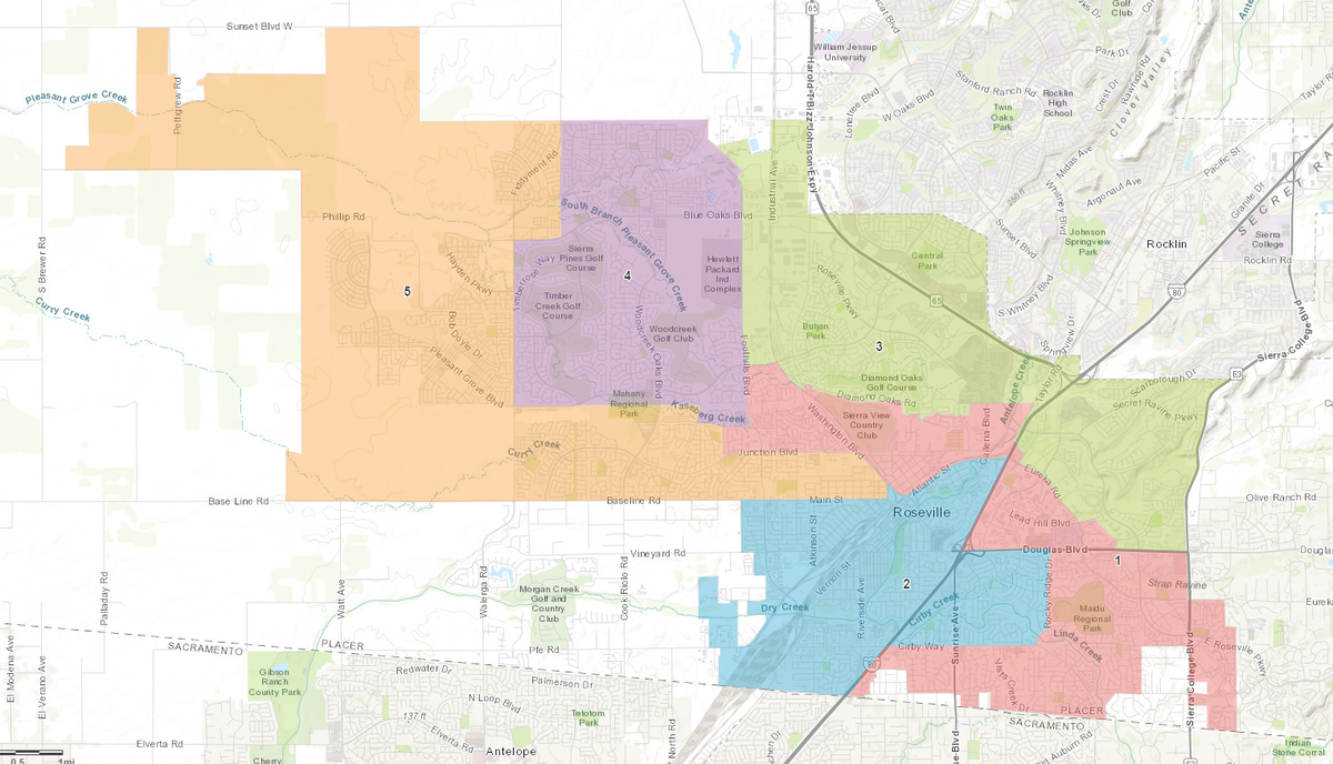
Consultants’ map prioritized over others
After public hearings began on district-based elections in September, members of the public submitted more than two dozen district map drafts, with National Demographics later offering three maps based on suggestions in the public submissions.
Ultimately, the firm’s own Map 117 became one of the focus maps for the council, which was designed to ensure “that each district encompasses a diverse set of neighborhoods and concerns, and no one area is dominated by one council member,” according to the firm’s commentary. That map was updated to 117B, which kept two west Roseville neighborhood associations together in one district.
The other three focus maps — 106, 113 and 122 — were all submitted by members of the public. In all three of those maps, at least one district encompassed the residences of two current council members.
Variations of Map 117 are the only ones that seem to prioritize where each council member currently lives, said LaMills Garrett, an east Roseville resident, during the Nov. 20 council meeting.
“If one attempted to split the city horizontally, vertically, along natural boundaries, along communities of interest, along majors streets, it is impossible to arrive at Maps 117 or 117B,” he said, “without determining that incumbency is more important than all other factors.”
Maps considered for district voting

Source: City of Roseville
At that public hearing, Map 106 garnered significant public support from residents. In that map, Councilman Bruce Houdesheldt — who was appointed to his seat earlier this year — wouldn’t be able to run again when his term ended in 2020. That’s because under Map 106, his home would be in Krista Bernasconi’s district, and she isn’t up for election until 2022.
Houdesheldt denied that ensuring he would be able to run in 2020 was a factor in his support for Map 117B.
“I never had that conversation,” he said. “I’m not a politician, I’m a public servant. I’ll certainly be up for reelection in 2020, and I hope that I’ve done a good job to get elected to a full term.”
Elected officials drawing their own districts is an inherent conflict of interest and when they do that, their primary concern is often protecting their own seats, said Dan Vicuna, the national redistricting manager at Common Cause, an organization that promotes government transparency.
“It’s a process in which elected officials have the final say, and not a situation where the public had an opportunity ... of being the ultimate decision makers,” Vicuna said.
East Roseville split under approved map
Councilwoman Pauline Roccucci said she supported 117B because it was the “best map to choose during this time of transition.”
Part of the process of switching to district-based elections means helping maintain a continuity of governance, she said.
“This is a real period of transition to help us go from at-large to district, and maintain the will of the people who voted for the last council members,” Roccucci said. “The will of the people is to have them run.”
Houdesheldt said 117B is a better map than 106 because “it’s better for areas to have more than one person representing their interest” — in this case, east Roseville being split into three different districts.
Under the California Voting Rights Act, which took effect in 2003, at-large elections are prohibited if they prevent minority groups from influencing the outcome of an election by diluting their votes across a municipality.
The idea is that by segmenting minority voters across separate districts, non-minority candidates can easily pass over those minority-majority neighborhoods and still win, while minority candidates may struggle to gain traction.
Under Map 117B, most Latino eligible voters would be in Districts 2 and 5, and most Asian American voters would be in districts 1 and 5. There are no geographic concentrations of African American or Native American eligible voters, according to National Demographics.
“I wanted something to keep unity for the city as a whole,” Roccucci said.
Scott Alvord, who was the only councilman who voted against 117B, said he appreciated that all active neighborhood associations were not split by district lines in the variation. But that ultimately, he “voted my conscience.”
Alvord said it was “kind of hard to justify” the splitting up of east Roseville. “I didn’t feel or get the impression that was desired” by residents there, he said.
He said that avoiding ousting a fellow council members may have factored into the rest of the council’s decision.
“Frankly I’m shocked that it was 4-1,” Alvord said.
Bernasconi could not be reached for comment.
Firm’s founder testified on gerrymandered maps
The demographers behind the map the Roseville City Council selected has faced similar accusations of incumbent protection and gerrymandering in the past.
Last year, National Demographics was hired to draw district lines for the city of Martinez. The council selected a map where three council members who live within 1,000 feet of each other still ended up in three separate districts.
Two residents later sued the city of Martinez after the November 2018 election, arguing the new district map “reflects its impermissible predominant consideration of incumbent residence,” as reported by the Martinez News-Gazette.
This year, the firm’s founder and president, Douglas Johnson, was also involved in a gerrymandering case in North Carolina. Johnson was an expert witness for Republican lawmakers defending the state legislative lines they drew.
Johnson later admitted his testimony was flawed, and included several errors, according to The News and Observer in Raleigh. A three-judge panel overseeing the case ultimately struck parts of his testimony. The panel later ordered the legislature to draw up new maps, saying the Republican-drawn maps show signs of “extreme partisan gerrymandering.” On Monday, the panel approved new maps for the upcoming year.
The city of Davis, which has gone through the process of switching to district-based elections this year after receiving a demand letter, had also considered using National Demographics as a consultant in August.
The city ultimately hired Paul Mitchell, a local demographer, to draw district lines for the City Council. Mitchell specifically asked not to be told where current council members lived before drafting the maps, according to the Davis Enterprise.
The maps Mitchell drew for a five-district system had some current council members ending up in the same district. Last month Davis approved a new district map for the November 2020 election.
“To chose a map that ignores incumbent protection or to order the demographer to ignore incumbent protection, would be a clear demonstration of interest in a fair and community-driven process,” Vicuna said.
Roseville city staff was aware of Johnson’s role in the North Carolina case prior to recommending his firm, according to city spokeswoman Megan MacPherson. But the staff was attracted to the firm because of positive references and its past work with several other cities in the state.
“With the 2020 election coming up, the timeline is really tight and we needed to go with a known experienced firm,” MacPherson said. “We were really impressed with the robust civic engagement the firm uses and that level of transparency is very important.
Approved map unlikely to last long
Issues raised in the Roseville case may soon be addressed by a new law signed by Gov. Gavin Newsom, which strengthens public input on how cities and counties draw their maps.
Under the Fair Maps Act, “geographic integrity of any local neighborhood or local community of interest shall be respected.” The law further clarifies that communities of interest do not include “political parties, incumbents, or political candidates.”
Though the council approved the district lines of Map 117B last month, nothing legally binds the council to the map. The council approved its new ordinance officially switching the city’s elections to a district system during its Wednesday meeting.
In theory, the council could still throw the map out all together. But city officials note that delaying the implementation of the map past Dec. 4 would put Roseville out of the “safe harbor” period. During that time, attorneys and law firms cannot threaten to sue the city for being out of compliance with the California Voting Rights Act.
Leaving the safe harbor period would mean Roseville could get hit with a demand letter, which could lead the city to paying up to $30,000 in attorney fees even if it creates a new district map on time.
During Wednesday’s city council meeting, Alvord said “I’m pretty certain that even if I was to propose not accepting this and changing the map again, I kind of don’t think it’s going to happen.”
“I think it’s important that at this point now we take the loss on the map move forward and go to districts and get it right with some committees that help design this down the road,” he said during Wednesday’s meeting.
Some city council members highlighted that the district map selected will only be used for this upcoming election. Council terms are four years, and seats for Districts 1, 3 and 5 will be up election in 2020.
Once the new 2020 U.S. Census Bureau data is released the following year, the city will be required to redraw its map to reflect the new population data. With significant growth in the last decade in west Roseville, the new district borders could look dramatically different.
The council directed the city’s charter review commission last month to look into how the city will draw district lines in the future, the creation of an independent citizens redistricting commission — an increasingly common tool used by California municipalities — has not been officially approved.
At the Nov. 20 city council meeting, Mayor Allard indicated he would continue to support Map 117B for the November 2020 election.
“Sometimes we have to make tough votes, and the problem is after you make those tough votes you need to stick with them,” Allard said. “I think we need to swallow it.”
This story has been updated to include information from Roseville City Council’s most recent meeting.
This story was originally published December 4, 2019 at 1:21 PM.