
First rains of year didn’t bring much to Northern California — but another storm is coming
In some places, more than an inch of precipitation fell Friday in Northern California while other places, including Sacramento, saw only a fraction of that.
Whatever came down in the first rains of the season were a mere drop in the bucket.
The precipitation, the first for the rain year that began Oct. 1, measured .15 inches in downtown Sacramento, according to the National Weather Service. That puts the city at 8% of normal for rainfall this year, according to weather service records.
Sacramento Executive Airport received less — just .04 inches. The average value for this time of year is 0.76 inches.
Other places in the capital region, north of Highway 50, got comparably more. Fair Oaks, for example, had the most in Sacramento County with .42 inches with Orangevale and Antelope receiving a little more than a third of an inch. For Yolo County, far less than a tenth of an inch fell — Davis received .06 inches while Woodland had only more than a trace.
Placer County’s Sierra slopes saw an inch of rain or more with Alta (1.88 inches), Blue Canyon (1.5) and Foresthill (1.43) receiving the most. Auburn saw more than a half-inch while Roseville received about a quarter-inch of precipitation.
In El Dorado County, Georgetown got 1.45 inches while Placerville gauges saw six-tenths of an inch and more across town. Farther north, Nevada City received 1.73 inches, according to the weather service’s roundup of totals.
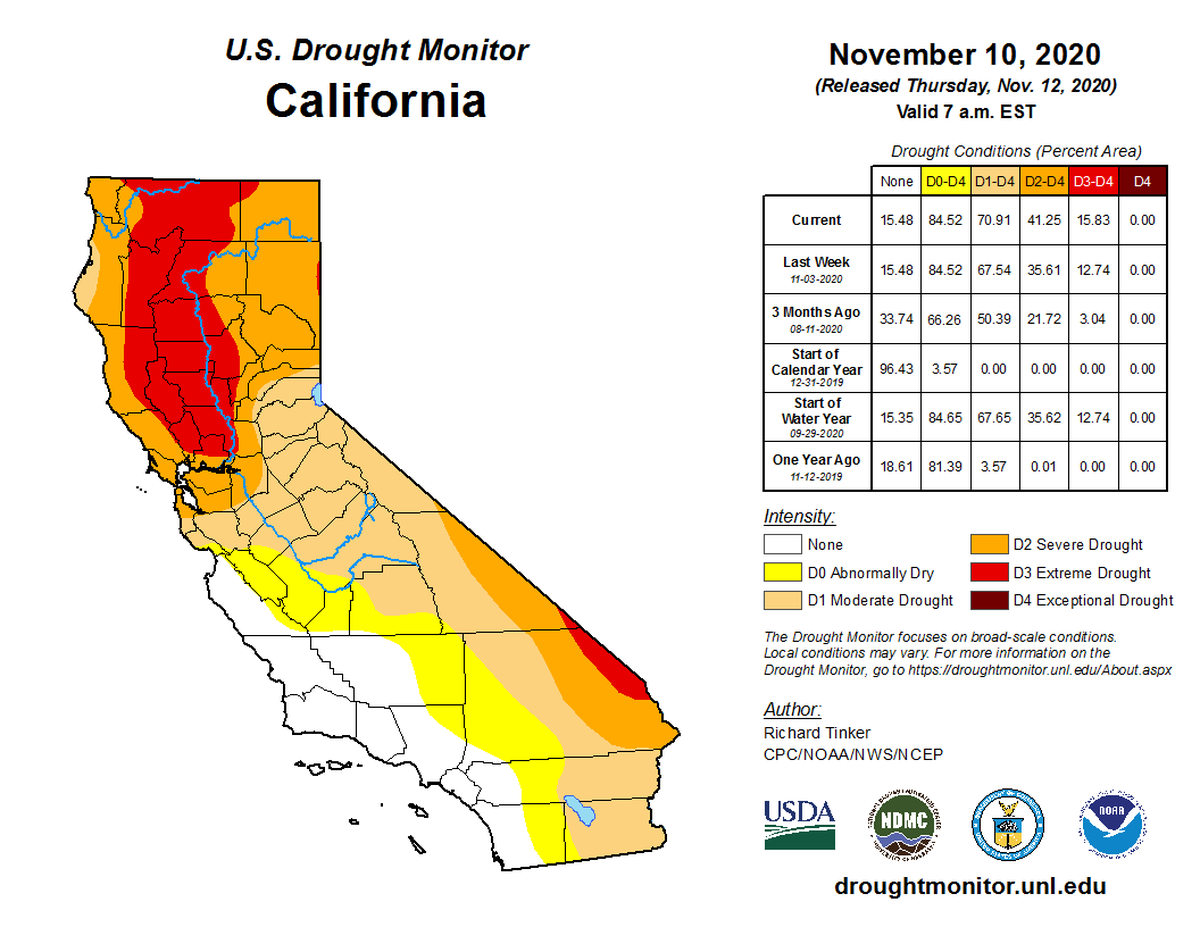
Still, drought conditions persist across most of the state, according to the U.S. Drought Monitor at the University of Nebraska-Lincoln. Climatologists there said about 70% of the state was in moderate drought or worse last week with nearly 16% of the state — mainly along the western Sacramento Valley including Yolo County — in “extreme drought.”
Rain, snow in fire areas
In fire-ravaged Butte County, Jarbo Gap saw an inch and a half of rain, prompting some concerns for mudslides in the North Complex burn areas. Forest officials said in an update earlier in the week that it had shifted operations to Oroville from Quincy “as higher elevation areas become less accessible for suppression repair and hazard tree removal.”
Firefighters said “there is significant heat remaining in lower elevation areas not covered by snow.” The fire, which charred more than 300,000 acres and killed 9 people, was about 98% contained with “full containment a week or two off, weather and operations dependent.”
Still, with the rains, “longer-term hazards include landslides and flash flooding caused by erosion or suppression activities not yet repaired.”
In the southern Sierra Nevada, snowfall was helping firefighting efforts against the Creek Fire in Fresno County. It’s one of a handful of the season’s major wildfires still active.
Highway 50 has snow along the sides of the roadway beginning near Twin Bridges. Highway 80 also has snow, beginning near Kingvale. Chains are not currently required on either highway.
Alex Hoon, a meteorologist at the National Weather Service in Reno said that Truckee reported an inch of snow, while Squaw Valley and Alpine Meadows each reported 9 inches at their summits and 2 to 5 inches at their bases. Homewood Mountain Resort reported 2 inches at its base and 3 inches at its summit.
Resorts, however, remain closed this weekend — but some are still planning to reopen closer to the Thanksgiving holiday.
The weather system that brought the rain and snow also came with strong winds east of the Sierra, with a high of 111 mph gusts coming across Squaw Summit, according to the National Weather Service in Reno. Across the Tahoe area and Reno, winds ranged from 50 to 70 mph. The Reno-Tahoe International Airport closed temporarily due to 58 mph gusts.
What’s in the forecast?
A new storm system is coming on Tuesday night , with showers continuing on into Thursday, forecasters said. The fast-moving storm could bring 3 to 10 inches of snow to the Sierra, with snow levels staying around 6,500 feet again.
Donner and Carson passes, the summits for Interstate 80 and Highway 88, are expected to get 6 to 8 inches of snow, while Highway 50 over Echo Pass could see 1 to 2 inches.
The storm will also bring strong winds on Monday night, with strong gusts reaching the Tahoe area on Tuesday. By Wednesday, the winds will subside into a breeze.
In the Valley areas, the storm will bring rain ranging from a half-inch to an inch in Sacramento. In the foothills, 2 to 3 inches of rain are expected on Tuesday and Wednesday.
This story was originally published November 14, 2020 at 12:53 PM.