Central Valley forecast: How much heat will we see in first week of summer?
It was a magnificent Juneteenth weekend to get outside, with high temps anywhere from 5 to 10 degrees below average on Friday and Saturday across the Central Valley — not to mention the sunny skies and a light breeze.
But now that summer is officially upon us — the summer solstice occurred at 1:24 Sunday morning — that summer heat is back and building through the start of the week. High pressure over the Pacific Northwest is strengthening through Wednesday. Underneath this mass of building air, much of California and the western U.S. will experience well-above-average temperatures that will continue to keep skies clear and dry out the area.
As this high-pressure ridge reaches its peak between Tuesday and Thursday this week, much of the San Joaquin Valley will see temps nearing and exceeding 100 degrees and very low humidity. Relative humidity values below 15% south of Modesto and Fresno will raise the possibility of wildfire activity.

Thankfully for Sacramento and the Delta region, a nice and steady Delta breeze will keep the area a bit more moderated, with high temps in the low- to mid-90s between Monday and Thursday. You’ll surely feel that Delta breeze if you are out around sunset, with afternoon and evening gusts of 20 to 30 mph all week long.
By the weekend: cooler temps in sight
Here is a quick and easy way to think about the weather: If it ever feels too hot or too cold where you are, just know that somebody else is likely saying the opposite somewhere not too far away.
That rule holds true this week. While we feel the heat of summer return, some Alaskan fisherman will likely find these next few days to be a bit chillier than they might expect. That is thanks to a trough of developing lower-pressure air higher up in the atmosphere through Thursday. This trough will feed of the high-pressure ridge across the Pacific Northwest, and move in to fully replace it between Thursday and this coming weekend. In doing so, much of the western U.S. will suddenly be on another rendezvous with cooler temps.
This development has its drawbacks. For one, the orientation of this strong trough across the Pacific Northwest will force a significant westerly breeze across Central and Northern California as it arrives. Wind gusts across mountain tops and through valleys, and even along the coast, could top 30 mph. That means an increased risk for wildfires after a rather hot and dry past few weeks.
We will have more on this potential wildfire risk later this week.
This week’s forecast
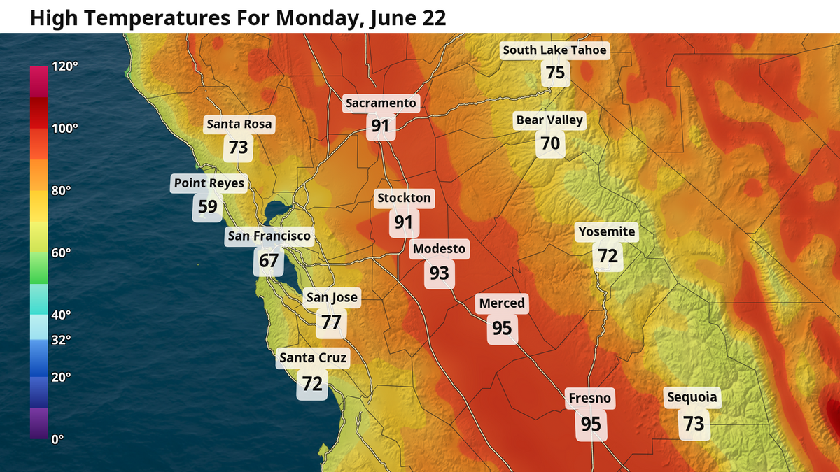
Sacramento: Highs rise back to around 90 degrees Monday as skies remain clear. The new high pressure ridge over the Pacific Northwest will to strengthen through Wednesday, pushing high temps into the mid-90s. Overnight low temps will hold steady in the 50s all week. A decently strong Delta breeze, with gusts of 20 to 30 mph, will keep those hot afternoon temps a bit cooler compared to the rest of the Central Valley. That Delta breeze hits a new level between Thursday and Friday; the arrival of the Pacific Northwest trough will force westerly winds into the Sacramento area that will further push temps down into the 80s through the weekend. Clouds could even appear Friday morning, marking the arrival of the next cooldown.
Fresno: High temps Monday will already be closing in on 100 degrees by Monday afternoon. And even if Fresno Yosemite International Airport falls short of recording 100 degrees by later in the day, many parking lots and paved surfaces are sure to be significantly hotter. The heat continues through Thursday as overnight low temps climb to around 70 degrees and afternoon highs run between 100 and 105. Very low relative humidity values of 10% to 15% will create a mild wildfire concern at the very minimum. Any cooling by the weekend will be more moderate compared to Central and Northern California, and the increase in wind speeds will bring an additional wildfire concern.

Modesto: High temps in the mid 90s will hold stable through Thursday. Modesto will benefit from the same Delta breeze that Sacramento will, keeping temps from flirting with 100 degrees unlike Fresno. Depending on the strength of the Delta breeze when the trough arrives between Thursday and Friday, daily high temps are likely to be between the mid-80s and low 90s this coming weekend.