Temperatures to stay mild as Sacramento and the Central Valley roll into July
It truly was a gorgeous last weekend of June, with much of the Central Valley experiencing well below average high temperatures and even a few passing clouds. Across many of the Central Valley’s major cities, high temperatures on Saturday were generally recorded at between 10 and 13 degrees below average for this time of year.

And here’s some news to carry you through the week: It doesn’t stop now.
That’s because the trough of low-pressure air in the upper atmosphere that brought us cooler temps will be sticking around through at least the start of July, with a potential for more of these mild temps to stick around just a bit longer.
So what does that mean for your plans as we are looking through the week and towards the July 4 weekend? Well easy to say, the weather won’t be unbearably hot during this entire stretch. Sure, 88 to 92 can feel hot with the mid-afternoon sun, and it is always important to hydrate, but no day this week or weekend will be a true burden to your outdoors and holiday plans across the Central Valley.

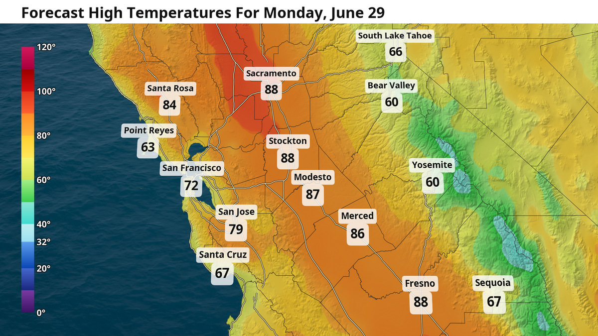
This Monday will actually be the warmest day this work week for much of the Sacramento Valley, with high temps in the upper 80s and low 90s. The Delta breeze will be relatively weak this afternoon, so don’t be surprised if some spots, especially in downtown Sacramento, reach into the 90s Monday.
That breeze picks back up Tuesday with a slight cool down for temps there on out. You can look forward to high temps in mid- to upper 80s for much of the Central Valley between Tuesday and Saturday. Temperatures will be slightly warmer from Fresno south to Bakersfield, closer to 90 degrees, but even then they will still remain below average.
Meanwhile, the eastern U.S. will bake
As is often a good rule to follow when tracking atmosphere, “look for the opposite just removed from your sky.” Perhaps that’s a bit vague, but here me out. This is on perfect display this week.
While California sits rather comfortably this week with mild temps, the other side of the country — the sky just removed from ours — will be experiencing an extremely intense heat wave. Temperatures in portions of the Midwest, Southeast, and Northeast could reach above 100 degrees heading into the July 4 weekend.
This is thanks to our upper atmosphere. While the low pressure trough parks itself over California and the Pacific U.S. states, the rest of the atmosphere will get tangled in a large “heat dome” that will dominate the skies. The easiest way to think of this: There is literally “less” atmosphere in California this week while there is “more” of it out east. These intense heat waves are sometimes referred to as heat domes given how this pattern can redirect the jet stream in a near circle around the high pressure area.
Some heat dome events can last for weeks at a time, but this one thankfully will not. By Sunday and the following week, early signs point to a return to normal as our trough erodes along with our cooler temperatures. The Climate Prediction Center, a specialized branch of the National Weather Service, is expecting a greater likelihood for above-average temperatures for California in the second and third weeks of July.


So for now, enjoy these easier temps while you can. Later this week, we will be highlighting expected weather for fireworks shows across the area.
This story was originally published June 29, 2026 at 6:00 AM.