
Flood danger to increase across Northern California as another major storm strikes
The strong winter storm forecast to arrive Monday will likely stress the Sacramento region’s already raging rivers, creeks and tributaries.
However, local and state authorities are closely monitoring several flood-prone areas and the region’s major dams and reservoirs are expected to hold.
Both Shasta and Oroville, by far California’s two largest reservoirs, are below 50% capacity, even as the amount of water flowing into the lakes far exceeds the amount being released. Smaller reservoirs in the region, including Folsom, New Bullards Bar and Camanche, are above their historical average levels for this time of year, but are well below capacity.
“California’s signature reservoirs (Shasta, Oroville and Folsom) that are connected to the Sacramento River should have enough capacity within the system to absorb the precipitation from these incoming storms,” David Rizzardo, manager of the state Department of Water Resource’s Division of Flood Management’s Hydrology Section, said in an email.
Rizzardo said increased releases from Folsom Lake, as well as “flow in uncontrolled streams and creeks” will lead to some points on the Sacramento River reaching a flood monitor stage. The river at the I Street Bridge, for example, is predicted to hit its highest level in years, reaching monitor stage Monday and remaining there through the week. That could lead water officials to opening the Sacramento Weir – a relief valve of sorts that sends water pouring into an area near the Yolo bypass – for the first time since 2017.
Folsom Lake, sitting above the vast Sacramento metro region, will certainly also be a focus for water officials, but there appears to be little cause for concern, said Jay Lund, director of the Center for Watershed Sciences at UC Davis.
“Folsom is pretty full for this time of year, but I think it’s in a comfortable stage,” Lund said. “(Water officials) have their smartest people watching that one and they pay a lot of attention to that reservoir.”
The greater concern appears to be with smaller bodies of water. The National Weather Service said Friday that “record river levels” were possible in Northern California during this week’s storm, and some of the region’s creeks and tributaries are already showing signs of trouble.
The Cosumnes River is forecast to reach a flood stage Monday night and remain there until Tuesday at Michigan Bar, east of Rancho Murieta near the Sacramento-El Dorado county line. Sacramento County emergency officials on Sunday issued an evacuation warning for Wilton near the Cosumnes.
“We are urging residents to get out now while roads are still clear,” authorities said. “Don’t wait for an evacuation order.”
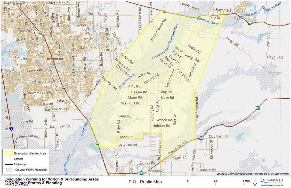
The Cosumnes could also approach its flood stage near Highway 99. The Mokelumne River is forecast to reach flood stage late Tuesday at Benson’s Ferry, near Interstate 5.
The Bear River in Yuba County had been forecast to briefly reach a “danger stage” early Tuesday, nearly 2 feet higher than the river’s flood stage, according to the California Nevada River Forecast Center. The river was forecast to enter a danger stage at a monitor along Highway 65, just south of Wheatland.
That projection was downgraded significantly through the weekend and the river is now forecast to reach its monitor stage early Tuesday.
Russ Brown, a Yuba County public information officer, said emergency officials don’t expect Wheatland or other densely-populated areas to flood. The Bear River borders rural farmland and the Feather River, into which the Bear River empties, appears to have the capacity to absorb the flow.
“There are areas where the water can go without creating a risk to life and property,” Brown said.
Even communities at higher elevations are at risk. The city of South Lake Tahoe warned residents that if the storm is warm enough to melt snow, the community could see flooding. “The flooding threat is heightened due to existing snow and ice on the ground and streams and river basins that are already elevated after numerous storms,” city officials wrote in an advisory.
This story was originally published January 9, 2023 at 6:00 AM.